
The Rolwaling Valley lies inside the Gaurishankar Conservation Area in Dolakha District, between the Langtang and Everest regions and close to the Nepal–Tibet border. It is a narrow glacial valley of Sherpa villages, high lakes and 7,000 m peaks, and it sees only a small fraction of the trekkers who walk in Everest or Annapurna. If you want a Himalayan trek with real solitude, simple teahouses and strong local culture, Rolwaling is one of Nepal's best choices.
| Detail | Information |
|---|---|
| Location | Rolwaling Valley, Gaurishankar Conservation Area, Dolakha District |
| Main Highlights | Tsho Rolpa Lake, Beding village, Na, Sherpa culture, views of Gaurishankar and Menlungtse |
| Typical Trek | 10–12 days from Kathmandu (return) |
| Highest point on the standard trek | sho Rolpa, about 4,580 m |
| Difficulty | Moderate to strenuous. Remote trails, steady altitude gain |
| Best Season | March–May and September–November |
| Accommodation | Basic teahouses and simple lodges |
| Advance Option | ashi Lapcha Pass (5,755 m) into the Everest region. Technical, for experienced trekkers only |
Tsho Rolpa (about 4,580 m) is usually described as Nepal's largest glacial lake. Its grey-turquoise water sits below the Trakarding Glacier and a wall of ice peaks. The lake is monitored because of glacial lake outburst flood risk, and it is also a clear, visible example of how Himalayan glaciers are changing. Most trekkers reach it as a long day hike from Na.
Beding (about 3,690 m) is the cultural centre of upper Rolwaling and the main stop for acclimatization. Expect stone houses, a village monastery, chortens, mani walls and potato fields, with Gaurishankar and surrounding peaks above the village.
Na (about 4,180 m) is the last settlement before Tsho Rolpa. It is a high yak-herding hamlet with a few simple lodges, and it is the usual base for visiting the lake and the glacier.
Simigaon (also written Simigau) and the villages around it make up the first cultural stop on the trail. Trails here pass through terraced fields, bamboo and rhododendron forest, and suspension bridges over fast rivers.
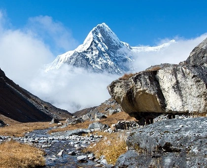
Gaurishankar (7,134 m) and Menlungtse (7,181 m) are the best-known peaks of the valley, shown at their best from the upper trail near Beding and Na. Gaurishankar is sacred to both Hindus and Buddhists.
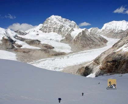
Tashi Lapcha is a high glacier pass that links Rolwaling with Thame in the Everest region. It is a serious mountaineering crossing, not a normal trek. It involves glacier travel, crevasses, ice slopes, fixed ropes and camping at high altitude. It adds about 5–7 days to the trip and is suitable only for experienced trekkers with mountaineering skills, a strong guide team and proper equipment. Weather and glacier conditions decide whether a crossing is possible in any given season.
The conservation area includes subtropical forest, oak, rhododendron, pine and juniper, then alpine meadows and rock. Habitat for Himalayan tahr, musk deer, red panda and snow leopard exists here, although sightings are rare. Bird watching is rewarding in spring.
There are no flights to Rolwaling. The journey is by road and on foot.
Road work in this valley is continuing, so the point where trekking starts can move further up the valley from year to year. Ghumnajaau checks current road conditions before every departure.
Times and altitudes are approximate. Your final plan depends on the season, the road and group fitness.
With a spare day built in for weather or slower acclimatization, the trip works well as a 12-day plan. Add 5–7 days for a Tashi Lapcha crossing.
Expect basic teahouses and family-run lodges in Simigaon, Dongang, Beding and Na. Rooms are shared or twin rooms with simple beds, and toilets are usually outside or shared. Electricity and Wi-Fi are limited or unavailable, and hot showers, where they exist, are paid extras. This is an authentic trekking experience, not a luxury one.
The Rolwaling trek needs two permits, and a Tashi Lapcha crossing into the Everest region adds more. Ghumnajaau arranges all of them.
| Permit | Fee | Notes |
|---|---|---|
| Gaurishankar Conservation Area entry permit | NPR 3,000 | Required for the Rolwaling Valley trek |
| Restricted area permit | US$20 per week | Charged for each week of the trek |
| Sagarmatha National Park and Khumbu permits | See our Everest Region page | Only if you cross into Khumbu, for example over Tashi Lapcha Pass |
Fees change, so we confirm current rates when you book. Bring your passport and a few passport photos.
How difficult is the Rolwaling Valley trek?
It is moderate to strenuous. Daily walking is 5–7 hours, the trails are remote and some days climb steeply. The Tsho Rolpa day is long at altitude. Good fitness and a proper acclimatization day are important.
How many days does the Rolwaling Valley trek take?
A standard Tsho Rolpa trek takes 10–12 days from Kathmandu and back. A Tashi Lapcha crossing to the Everest region adds roughly 5–7 days.
Do I need a guide for Rolwaling?
A licensed guide is strongly recommended, and is required for the Tashi Lapcha Pass. Ghumnajaau provides experienced guides and porters.
Is Rolwaling suitable for first-time trekkers?
Fit first-time trekkers with some time to prepare can complete the Tsho Rolpa trek. Tashi Lapcha is not suitable for beginners.
What is the best time for the Rolwaling trek?
March–May and September–November.
Rolwaling is not for everyone, and that is exactly what makes it special. If you want untouched Himalayan landscapes, genuine Sherpa culture and a trek without the crowds, we can plan it for you, from permits and transport to guides and acclimatization days.
Contact Ghumnajaau today to plan your Rolwaling trek.



We create unforgettable trips, customized for your group.